
All solutions

Farm management platform (FMS)

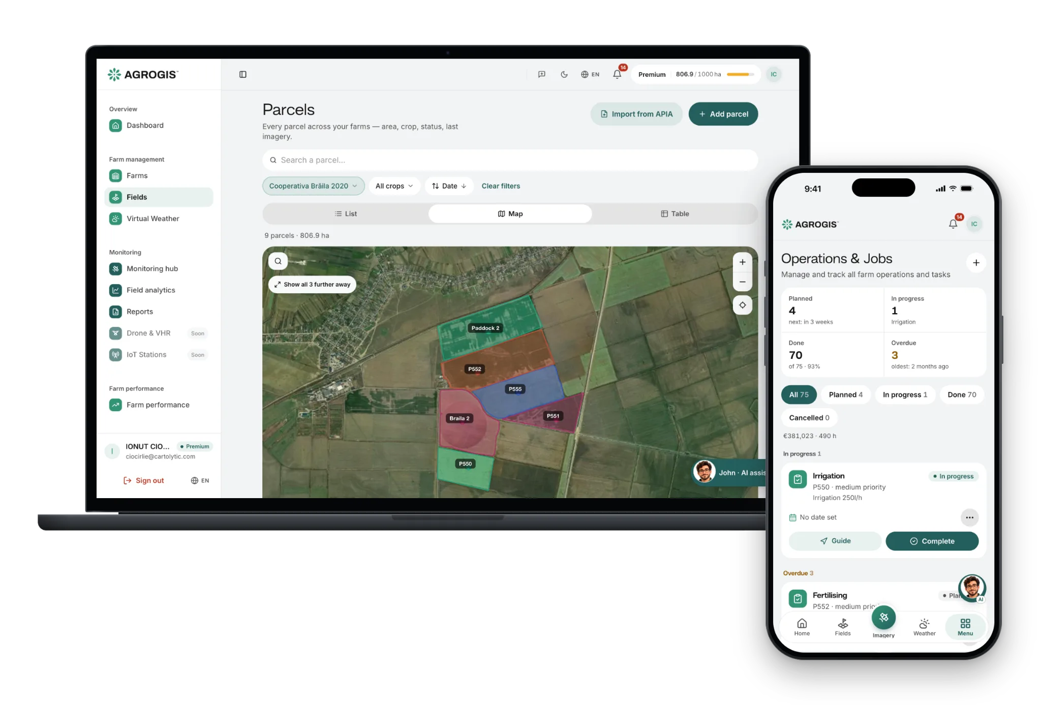
Your whole farm in one place: parcels, jobs, treatments and harvests, on the map and on your phone.

Keep a record of every parcel without notebooks and spreadsheets: what you sowed, what you applied, when, and who did the work. Satellite images and the weather sit on the same parcels, and the app works the same on a phone as on a computer.

One account
parcels, jobs, treatments and reports
Phone and PC
the same app, in the browser or installed
Your team
on paid plans, each person with their role
30 days free
on up to 10 ha, no card
One season on one farm

The season as a record, field by field

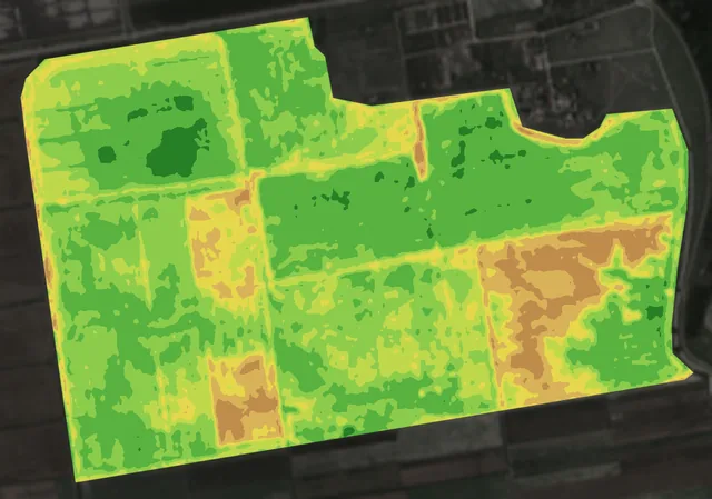
The same 320 hectares in the Bărăgan plain, 2025: the fields, what happened on each, and where the map sent someone to look. Scroll: the map follows each step.

  1. 1

    Six fields, drawn once

    The farm’s 321 hectares are six fields, A to F, from 26.7 to 83.6 hectares: one outline, split along the farm’s own tracks.

    Draw them on the map, import them as GeoJSON, KML or KMZ, or bring them in from APIA.

    What you do: Draw your fields once: every image, job and record after that sits on them.

    bare soildense crop
  2. 2

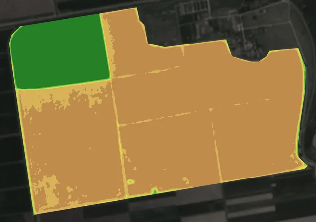
    Each field’s season, at a glance

    Field A, the winter crop, was harvested in mid-June. Fields B to F came up between 31 May and 5 June.

    Each field keeps its seasons year after year: crop, sowing, treatments, harvest.

    What you do: Record sowing, treatments and harvest on the field they happened on.

    bare soildense crop
  3. 3

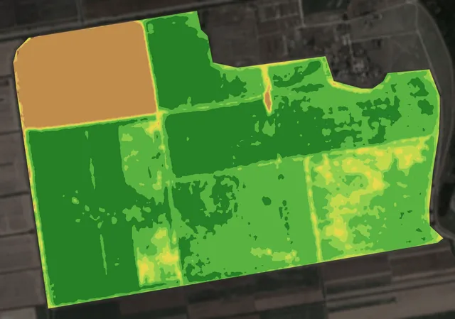
    A job where the map points

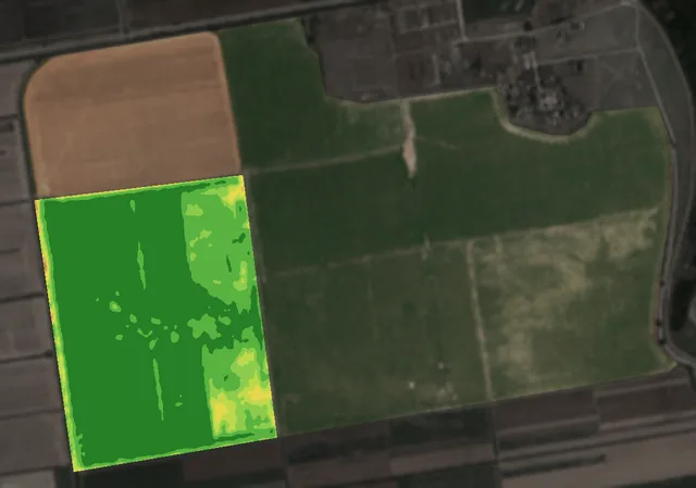
    On 18 June the map showed 15 hectares of field D growing weaker than the rest.

    A scouting job pinned to that patch, with photos taken on the spot, stays on the field’s record.

    What you do: Send someone to the patch, not across all 84 hectares.

    bare soildense crop
  4. 4

    Close the season, field by field

    Field A was harvested in mid-June, and the map showed it that week.

    When you close a field’s season you record the yield and the revenue, next to the jobs and what they cost.

    What you do: See at the end of the year what each field cost and what it brought in.

    bare soildense crop

Maps from 2025 Sentinel-2 images, in the same colours as in the app. Contains modified Copernicus Sentinel data 2025.

How the data moves

Public data goes in. Files your machines read come out.

AGROGIS is not a closed system. The standard imagery underneath it is public (Sentinel-2, Landsat), and everything it produces leaves in a format something else already understands.

Sources

  • Satellite imageryIncluded · a fresh view of every parcel, every few days
  • Daily high-detail imageryAdd-on · a new picture every day, down to 3 m
  • Weather modelsHourly conditions and a 7-day forecast, per farm
  • Elevation modelTerrain and slope across the parcel
  • Your boundaries and jobsDrawn, imported, logged

One workspace

  • Fields
  • seasons
  • jobs
  • team

What you take out

  • Prescriptions for the terminalISOXML · John Deere · Trimble · Ag Leader
  • EUDR due-diligence reportPDF evidence, loss drawn on the parcel
  • ISCC pre-screeningSame pipeline, 2008 cutoff
  • Spray registerCSV, XML and PDF
  • Your account dataJSON · GDPR, any time

What you get

Everything you need to make field decisions based on data — not assumptions. Features included in this solution:

  • / 01

    See every parcel on the map, with its crop and its history over several years

  • / 02

    Record every job in the field: sowing, treatments, fertilising, harvest

  • / 03

    Attach photos from the field, with the place they were taken

  • / 04

    Treatment register with product, dose, area and operator — export to CSV, XML or PDF

  • / 05

    Everyone in the team sees only their farms: owner, contributor, viewer

  • / 06

    Install it on your phone straight from the browser, no app store

How it works

How it works, step by step, from the first message to the result.

  1. 1

    30 days free, first field in minutes

    Sign up, draw or import your first fields, and the app is ready to use.

  2. 2

    Your data comes in

    Satellite imagery attaches to your parcels on its own, and so does the farm's weather on plans that include it — nothing to connect or install.

  3. 3

    Invite your team

    Add agronomists, drivers, accountants. Each sees what they need, nothing more.

  4. 4

    Work from the field or the office

    The app runs the same on a driver's phone as on an agronomist's laptop.

Technical details

For anyone who wants the exact numbers: sources, frequency, formats. For anything else, write to us.

Platforms
Web (Chrome, Edge, Safari, Firefox) and installable on a phone
Backups
Daily, kept for 7 days
Where your data lives
In the European Union (Frankfurt)
Languages
Romanian, English, Italian, Spanish, French
Trial
30 days, no card

Frequently asked

  • How much does it cost?
    There's a 30-day free trial with up to 10 ha. After that, paid plans scale with area and modules. See /pricing for full details.
  • Can I import fields from another app?
    Yes. Upload GeoJSON, KML or KMZ files, or tap a parcel on the map and check the boundary AGROGIS suggests from satellite imagery.
  • Does my data stay mine?
    Yes. EU hosting, GDPR-compliant, and we do not sell or share your farm data; the service providers we rely on are listed in the privacy policy. You can export your account data at any time, as a JSON file.
  • Does it work without internet in the field?
    Partly. The app installs to your home screen and needs a connection to open and to load data. If the signal drops while it is open, what is already on screen stays there, and the jobs, spray and fertiliser records, issues, expenses and stock entries you save are kept on the phone and sent by themselves when the connection returns (photos need the connection). Opening or reloading the app without a connection shows a “You are offline” page, which reloads by itself when the connection comes back.

Ready to start?

Try it on your own parcels, or tell us what you need — we reply within one business day.